Red Level 10 veld fire warning for parts of Limpopo
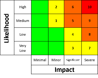
The South African Weather Service (SAWS) has issued a Red Level 10 warning for veld fire conditions in Thulamela (including Thohoyandou), Musina, Blouberg (including Alldays) and Lephalale, valid from 10:00 to 18:59 on Tuesday 3 November. Level 10 is the highest level on SAWS's impact-based warning scale.
By Staff Reporter · Published


The South African Weather Service (SAWS) has issued a Red Level 10 warning for veld fire conditions in Thulamela (including Thohoyandou), Musina, Blouberg (including Alldays) and Lephalale, valid from 10:00 to 18:59 on Tuesday 3 November. Level 10 is the highest level on SAWS’s impact-based warning scale. SAWS says fires “may develop and spread rapidly” under these conditions and has told fire teams to be on full standby.
The South African Weather Service (SAWS) says that “conditions are such that the FDI index is above 75 in identified areas”. FDI is the fire danger index. Under these conditions, it says, “fires may develop and spread rapidly, resulting in damage to property and possible loss of human and/or animal life.”
- What changed: the Red Level 10 warning took effect at 10:00 and runs until 18:59.
- Who is affected: farmers, rural communities and anyone travelling in Thulamela, Musina, Blouberg and Lephalale today.
- What you can do: avoid any open fires today, and report smoke or flames to your local fire service at once. In an emergency, call 112 from a mobile phone.
SAWS’s instruction reads: “Fire teams, labour and equipment are to be placed on full stand-by. At first sign of smoke, every possible measure should be taken in order to bring the fire under control in the shortest possible time. All available aircraft are to be called for without delay.”
SAWS’s user manual says veld fire conditions can only be given Level 10 on its warning scale. The warning describes conditions in which fires could start and spread quickly. It does not mean fires are burning.
SAWS’s forecast also warns of extremely high fire danger in western North West, the extreme east of the Northern Cape, the Limpopo Valley and the Western Bushveld.
More: Storm Live · How SAWS warning levels work · All warnings
- SAWS warning matrix: weathersa.co.za
- SAWS warnings data and CAP feed: weathersa.co.za, caps.weathersa.co.za
Official source: https://www.weathersa.co.za/
How we make our journalism: every article is checked, edited and approved by our Editor-in-Chief before publication, and SAWS is credited for every warning we report. See our editorial policy.
Spotted an error? Read our corrections policy.