How do SAWS warning levels work, and what could they mean for voting?
Yellow, Orange and Red, Levels 1 to 10, and where veld fire warnings fit in. A plain guide to South Africa’s weather warnings, using today’s election-week storms as the example.
By Staff Reporter · Published


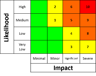
The South African Weather Service (SAWS) gives each warning a colour and a level by combining how bad the impact could be with how likely it is. On SAWS’s own matrix, Yellow covers Levels 1, 2, 3, 4 and 7, Orange covers Levels 5, 6, 8 and 9, and Red is Level 10 only. A Yellow Level 4 does not mean “a little worse than Level 2”: it means a significant impact is possible, though less likely. Veld fire warnings are always Level 10.
Two questions behind every warning
SAWS’s own guidance says the colour and number come from “combining the level of impact with the likelihood” of the weather (SAWS). In other words, every warning answers two questions: how much damage could this do? and how sure are we that it will happen?
The answers are placed on a matrix. On the SAWS matrix published on its website, Yellow warnings are Levels 1, 2, 3, 4 and 7, Orange are Levels 5, 6, 8 and 9, and Red is Level 10 only. Green, meaning minimal impact, sits on the matrix but is not a warning.
Why Level 4 is not simply “worse” than Level 2
Because the level mixes two measures, a higher number does not always mean a bigger storm. As reported by BusinessTech, Yellow Level 2 means “high likelihood, minor impact”, while Yellow Level 4 means “low likelihood, but a significant impact”. On the SAWS matrix, Levels 2, 6 and 10 are the high-likelihood levels, and Levels 4 and 8 are low-likelihood levels with bigger impacts.
So when SAWS has a Yellow Level 4 warning in place for severe thunderstorms with heavy downpours, hail and excessive lightning over northern KwaZulu-Natal and the Mpumalanga Highveld, as it does today, it is telling people that the storms may not reach everyone, but where they do, the damage could be significant. The Yellow Level 2 warnings over Gauteng and other areas mean storms are likely, with smaller impacts.
The SAWS matrix itself is published as an image, so check the full matrix on weathersa.co.za before relying on any one description of it.
How veld fire warnings fit in
The South African Weather Service (SAWS) has issued a Red Level 10 warning for veld fire conditions in Thulamela (including Thohoyandou), Musina, Blouberg (including Alldays) and Lephalale, valid from 10:00 to 18:59 on Tuesday 3 November. Level 10 is the highest level on SAWS’s impact-based warning scale. SAWS’s user manual says veld fire conditions can only be given Level 10. The warning is linked to the fire danger index (FDI): SAWS says “the FDI index is above 75 in identified areas”, and that under these conditions “fires may develop and spread rapidly”. The FDI itself is a separate SAWS product with its own scale.
A veld fire warning describes conditions. It does not mean a fire is burning.
What the warnings say about voting
Each SAWS warning lists the impacts it expects. Today’s Yellow Level 2 warning for severe thunderstorms over parts of North West and the Free State, valid from 14:00 to 21:59, lists “localised and short term disruption to municipal services and voting activities/processes” among the expected impacts, according to SAWS.
That matters because some voting stations have no walls. The IEC has 148 voting stations that are tents only, EWN reported. KZN electoral officer Ntombfuthi Masinga said that in some communities “there is absolutely no permanent structure”.
As of 10:35, SAWS had not issued any warnings for Wednesday 4 November. Every warning in force today expires by 23:59 tonight.
How to use a warning
- Read the area and the time. Every warning has a validity period. Today’s Gauteng warning runs from 12:00 to 21:59; northern KwaZulu-Natal’s runs until 23:59.
- Read the impacts. They tell you what SAWS expects: flooded low-water bridges, power cuts, falling trees or, today, disruption to voting.
- Follow the instructions. For today’s KwaZulu-Natal storms, SAWS advises: “If trapped in a vehicle during a flood, abandon it and climb to higher ground.”
- Check the source. Only SAWS issues official severe-weather warnings. Our forecast pages show model data, not warnings.
- “Yellow means it’s nothing serious.” A Yellow Level 4 warning means a significant impact is possible. Never call a Yellow warning “extreme”, but don’t ignore it either.
- “No warning means no storm.” It means SAWS has not issued a warning for your area. Thunderstorms can still happen, so check again later.
- “A veld fire warning means there’s a fire.” It describes the conditions in which a fire could spread fast.
- “The map and the text always agree.” Today SAWS’s forecast text mentions the extreme east of the Free State at Level 4, but its warning map lists no Free State municipality at Level 4. When they differ, check SAWS directly.
- SAWS frequently asked questions: weathersa.co.za
- SAWS warnings data and CAP feed: caps.weathersa.co.za
- Cape Town ETC, quoting the SAWS matrix: capetownetc.com
- BusinessTech: businesstech.co.za
- EWN on tent-only voting stations: ewn.co.za
- Our guide to SAWS warnings and how our forecast pages work
How we make our journalism: every article is checked, edited and approved by our Editor-in-Chief before publication, and SAWS is credited for every warning we report. See our editorial policy.
Spotted an error? Read our corrections policy.